- An Indian’s anguish on 2025 floods in the Hill states/Punjab and likely causes of large-scale damage. Next suggestions to prevent recurrence/reduce impact. Lastly, cause of floods in Chennai & Bengaluru. One can
blame Climate Change or look within/change. Respecting Nature was always part of Indian Tradition.
W.r.t. Punjab, Seema and Ravi wrote in The Tribune, “Years of silt build-up, uncontrolled construction and
development on riverbanks and floodplains and the neglect of drainage channels
have turned natural waterways into narrow paths. Thus transforming a natural
hazard into a man-made disaster.” Source
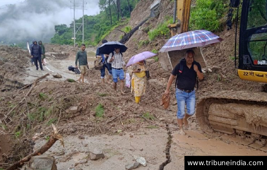
Cloudbursts
and floods in Uttarakhand, Himachal Pradesh and
Jammu region.
Weeks after the Dharali floods swept away lives and homes, the Uttarakhand forest department, despite warnings from environmental experts and the Ravi Chopra–led Committee, cleared 17.5 hectares of forests for the BRO’s Netala Bypass. The floods had also exposed timber mafia’s greed by carrying piles of illegally cut logs. Still reeling from the devastation of floods, locals are begging the government to stop.
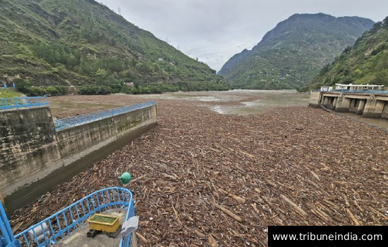 Logs of Wood in dams of Himachal
Pradesh.
Logs of Wood in dams of Himachal
Pradesh.
First Dharali & Harshil in Uttarkashi, next Tharali & Chepadon in Chamoli, then Jammu & Kashmir…
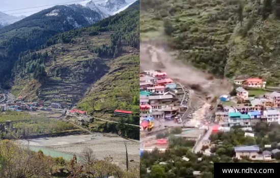 Cloudburst in Dharali, Garwhal,
Uttarakhand.
Cloudburst in Dharali, Garwhal,
Uttarakhand.
“The primary reason is the topography of the area, where heavy rainfall often results in landslides, sending mud and concrete into the rivers. These materials flow down with great force, accumulating momentum on the way, leading to flash floods downstream.” 5 Indian
Express
Nevertheless, in Himachal authorities push ahead cutting deodars in an eco-sensitive zone for the ropeway from Pirdi to Bijli Mahadev, ignoring cultural and ecological costs and warnings by locals…. Locals
protest against Ropeway
Landslides
in Uttarakhand have increased by a mammoth 3000% over last 10 years with over
4,600 landslides, 13,000 instances of floods, avalanches and cloudbursts. All
the construction in Uttarkashi, including roads and bridges are on flood ways
and terraces, many do not even have a drainage system.
Commercialising
of pilgrimage routes for shanty towns and cheap accommodation have increased
encroachment on river banks, forests, and dangerous slopes. Number of tourists is
beyond the carrying capacity of the Himalayan region.
Pilgrimages
were never meant to be four-lane tourist highways with Maggi wrappers and
plastic strewn across sacred forests. They were meant to test resilience,
introspection, and reverence for the divine. Garwhal needs devotees not tourists!
Despite the
1976 Mishra Commission warning against blasting fragile Joshimath slopes, the ₹12,000-crore Char Dham road project bulldozed
through forests and mountains. By 2023, Joshimath was sinking at 10 cm per
year, with cracks in over 850 houses and hundreds of families were
displaced. Read Ropeways to Kedarnath and Hemkund Sahib Are AVOIDABLE
According
to Uttarakhand State Transport Department data, 83,000 odd vehicles were
registered in the state during 2005-6. By 2012-13 this number went up to 180,000.
These consisted mostly of commercial cars, jeeps and taxis. Only 4,000 of these
were registered in 2005-06. In 2012-13 the number was 40,000.
In the June
2013 cloudburst more than 6,054 people were presumed dead, 300,000 remained
trapped in the valley, more than 110,000 were rescued. The evident co-relation
between increased tourism and higher incidence of landslides? Read about 2013 Embrace the Sacred, Dump the
secular
Illegal
mining across Himachal continues unchecked,
draining water channels and gutting valleys. Himachal doesn’t need more projects, it needs protection from stop axing forests and blasting hills.
Once rare, cloudburst, landslides, flash floods are a frequent affair now. A 2023 study found that extreme rainfall events in the country have surged 20–50% since the 1950s, a direct fallout of climate change. Over 45% of Himachal is already highly prone to landslides, floods & avalanches. Yet blasting continues in fragile zones. Since 2018, the state has seen 148 cloudbursts, 294 flash floods & 5,000+ landslides, costing ₹1,000-2,000 crore every year.
From
tunnels to highways, the youngest mountains on Earth are being shattered daily
for multi-lane roads and railway to reach pilgrim places?
Why are devotees allowed to go
for Yatras in the monsoon season? Safe evacuation of Manimahesh Yatris puts
additional pressure on the State administration, paramilitary forces and Indian
Army.
Cloudbursts in Jammu region
districts of Kishtwar, Doda, and Ramban, where settlements on fragile slopes
are easily washed away, were catastrophic.
The
short-sightedness of state policy makes disasters deadlier. For e.g. AIIMS
Jammu was built in a flood-prone khad, repeated dam projects in Kinnaur left
the Sutlej valley dangerously weak. Projects like the Char Dham highway and
railway tunnels in Ramban involving indiscriminate blasting of mountains in
Fragile Zones adversely impacted the environment.
River TAWI is
creating havoc in Jammu. Instead of providing greater space for it to transport
extra rainwater, the Tawi Riverfront project has narrowed the river channels to
include manicured gardens, multi-storey apartments, amusement parks, convention
centres, malls, hotels, and shopping complexes! Read Riverfront project in Jammu
destroying river
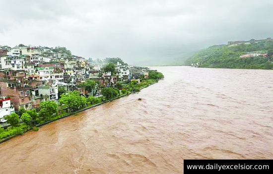 River Tawi, Jammu in 2025.
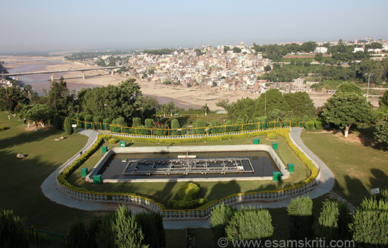 River Tawi in 2014, happier times. Pic taken from Bahu Fort, Jammu.
Can we not plan something without residential apartments, malls, hotels
etc?
Navjeev Digra, a founding member of Climate Front
Foundation (CFF) Jammu suspects that construction work on the central portion
of RFD covering the river island called Mandal could damage the ancient Ranbir canal structure running underneath across the river. Named after Maharaja Ranbir Singh, the 60 km long canal was built in 1905 to bring Chenab water for irrigation purposes in R S Pura and Samba tehsils in Jammu.”
Heavy rains
in 2023 and 2024 also saw water spill into residential colonies. Locals warned,
that the project is converting the river into a ticking flood bomb. Incidentally,
the Tawi River worshipped as Surya Putri,
receives wastes from 17 sewage nallahs and additional small drains.
Bridges and
real estate projects on floodplains across the Yamuna,
Ganga, and their tributaries have choked natural drainage and amplified floods.
The Yamuna floodplains in Delhi have been encroached by real estate projects,
the Commonwealth Games Village (2010) being the most known e.g. Today, even
moderate rainfall leads Yamuna to swell and flood colonies on its
floodplains.
River Yamuna
that flows through urban Delhi for 22 kilometres has its flood plains
obstructed by 4 bridges and a Metro line in just 170 metres. Each bridge having
14 pillars, 3/8 meters in diameter is erected in active course and bed of
Yamuna. Bridges on NH 24, Mayur Vihar, opposite Sarai Kale Khan, multiple
bridges and other structures between Wazirabad and Okhla are on floodplains!
Encroachments,
demolition debris, concrete waste, dumping, levelling, raising riverbed,
plastic waste etc., have been choking the river bed. Yamuna is reduced to an
open sewer with tonnes of untreated sewage, 2,000 MLD from 21 nallahs. Gasping
for her own life, Yamuna asserted her might in July 2023. Read article in
SANDRAP-Key Lessons from unprecedented
floods in Yamuna
It is human greed that is coming
in the way/ course of the rivers!
Floods
worsened in Mumbai because Mithi River, once lush with mangroves was turned into a stinking drain. Around 70% of the liquid in the Mithi is sewage, 30% garbage, and 10% is industrial discharge. The unchecked expansion of the city resulted in excessive dumping into the river, while BKC's land reclamation restricted the waterway dangerously close to its mouth. This year the Mithi River pushed back and flooded parts of Kurla, BKC and Santacruz, LBS Road, Taximan’s Colony and Kapadia Nagar.
Real Estate generates employment and revenue? Is there a way to regulate it?
1 Flooding in a village in
Kapurthala district of Punjab.
Devastating
floods in Punjab are the outcome of a
century of narrowing rivers, erasing wetlands, and building brittle
infrastructure in the name of development. It is the cumulative result of
colonial engineering, post-independence agricultural policy, unregulated urbanisation,
illegal sand mining and political choices that have left Punjab dangerously
exposed.
Further,
river beds not desilted since 1960, lack of maintenance of canals, flood plains
encroached, weak bundhs and cultivation on watercourse. 4
A 2023
Revenue Department survey exposed that
more than 7,000 hectares of illegal colonies sit on the floodplains of the
Sutlej and Beas. Water this year had only one path; into villages, homes, and fields. “Kahan Singh Pannu, former secretary, Water Resources Department, Punjab, pegs the annual cost of maintenance of rivers at Rs 3,000 crore” but state government/farmers cannot think beyond free power.” Read Why Punjab cannot escape blame for floods
Prof Ramesh
Kanwar told The Tribune, “We need to have enough land cover under watersheds and manage these in a way that much of the rainwater is absorbed, channelled through a good drainage system or goes into the groundwater instead of going as run-off.” 1
Silver
Lining-Heavy flooding might have re-charged the ground water levels.
On 20
August 2025, just 35 mm of rain in two hours left Chandigarh’s northern sectors under knee-deep water. The city’s premier medical institution, PGI was submerged, rain water infiltrated even the critical zones. Mohali and Ludhiana fared no better.
 A damaged Pathankot-Mandi Highway.
Bengaluru & Chennai flood repeatedly because lakes and wetlands have been erased by real
estate.
Read Why Chennai
floods every time it rains Excerpts, “The first reason is Chennai’s long history of vanishing lakes & water bodies, captured by rampant & unfettered urbanisation. Only 15% of Chennai’s wetlands are left, according to a study by Chennai-based Care Earth Trust, a biodiversity research organisation. Their findings show that Chennai’s built-up area grew from 47 sq. km in 1980 to 402 sq. km in 2012, while wetlands declined from 186 sq. km to 71 sq. km.”
Read Bengalureans
list what is drowning the city and Why
is Bengaluru suddenly prone to floods Excerpts, “Encroachment of lakes, tanks and drains, poor planning of drainage systems
and lack of regulation of floodplains have exposed Bangalore to the threat of
urban flooding, say experts.”
Concrete, Dams, and the Dying Rivers
Dams are
also fuelling floods. Sudden water release from the dam drowned 331 villages in
Belagavi in 2019. Two lakh people were marooned in Kolhapur & Sangli in
2019. Machchu dam collapse in 1979 wiped out thousands in Morbi.
When Bhakra
and Pong dams crossed 90% storage in July 2025, there was little buffer left to
absorb cloudburst inflows. Up to 45,000 cusecs water was released in a single
day. That torrent rushing into rivers stripped of their floodplains, weakened by
mining, amplified destruction downstream.
Dams in
Eco-Sensitive Basins have overrun Himalayan Rivers. By 2020, 80% of the
Bhagirathi and 65% of the Alaknanda had been dammed, despite clear geological
warnings, making the rivers more volatile. The 2013 Kedarnath floods destroyed
several such projects, showing their vulnerability.
Forests Don’t Grow Overnight
Drive for roads, ports, and power plants is stripping away forests, expressways slice through wildlife corridors, ports rise on fragile islands. These aren’t one-offs but part of a widening clash between development and ecology. Token sapling plantations cannot replace the loss of ancient, biodiverse forests, it is only ‘Green Washing’ the crime of deforestation!
In the last
hundred years we have lost 86 percent of our forest cover 77 percent of it in
the Himalayan region.
Take the example of Indore- the “cleanest city”. It has lost an estimated 250,000 trees in just five years, shrinking its green cover to a mere 9%. It is here where the “Ek Ped Maa Ke Naam” campaign claims to have planted 51 lakh trees!!
On World Environment Day, Indore saw the felling of 1,240 trees to pave the way for the Regal Square–Airport metro corridor. For Indore–Ujjain six-lane corridor, around 3,000 trees will be uprooted. For Smart City mission’s redevelopment plans in areas like MOG Lines, approximately 5,000 aged trees are tagged for removal. Airport-access road expansion threatens 445 trees, at MR-10 Square, 1,027 trees will be cut for six-lane flyover…
Every tree cut is not just timber lost, it is decades of shade, oxygen, and balance destroyed in a single stroke. Trees that survive the heat waves, trap dust, absorb noise, and give the city its character are being casually sacrificed for concrete. Development that bulldozes old banyans and neem groves, while promising to “plant saplings” elsewhere, is nothing but tokenism. A sapling takes years to offer the benefits of a mature tree, by then, the damage to microclimates and public health will already be done.
Ancient wisdom saw nature as sacred. The concept of environmental
protection is not a modern phenomenon for Hindu tradition, Shri Krishna lifting Govardhan
Parvat is not a myth but ecological guidance: forests and cows are shields
against natural fury. Our ancestors built with nature, not against it. Read
Indian Culture protects Plants
and Forests
The Cost of Concrete
But today,
forests and agricultural
lands are being taken over by environmentally one of the most destructive
industry, the construction industry. Concrete jungles do not absorb rain; they repel it,
pushing it back onto roads, homes, and lives.
Besides, concrete’s hunger drives a sand mining mafia across India.
This is not development. This is vandalism dressed up as progress. It’s sanctioned destruction. It is gambling with fragile ecology and human lives and calling it “infrastructure.”
Every new
road carved into a landslide-prone slope, every bridge built on a floodplain,
every dam blasted into a fragile mountain is an invitation to catastrophe.
Cement
Roads prevent water from seeping into the ground. The solution to bad asphalt
roads is better quality asphalt not always cement roads. Such roads always
contribute to rising temperatures during summers.
Hard
hitting, but true, flood preparedness in India remains reactive; focused on
post-disaster response rather than on preventive infrastructure to mitigate
future disasters. Governments typically spend far more on post-flood
compensation- funds are sanctioned, tenders are floated, contracts are signed.
Governments,
State and Central, must stop sanctioning ecologically disastrous projects and manufacturing
disasters!
When rivers rise, they are not flooding towns—they are reclaiming space we stole from them. Every axed
tree, every blasted slope, every river choked is a disaster scripted in
advance.
Food for thought
1. Maintaining of City level drains is whose
responsibility!
2. Good roads important but do we need 4 lane
highways in the hills!
3. Should Farmers not ask for Desilting of
Rivers instead of Subsidy esp. in debt laden Punjab!
4. Stone Mining in rivers needs to be tightly
controlled? Need new technology in construction that uses less of stone.
5. India needs to a find a sector beyond Real
Estate that contributes to GDP/Jobs.
6. Garwhal is for devotees not tourists. Stop
making pilgrimages, tourist resorts.
7. Himachal needs tourists yes but an
alternate development plan that protects the ecology of the region. Can it
higher educational institutions like IIT Mandi?
8. Needed “better
cooperation between Punjab, Himachal Pradesh and Jammu & Kashmir to ensure
synchronised water management.” 7
9. W.r.t. Punjab, “Encroachments on floodplains must be cleared
systematically and a rigorous land-use policy enforced to protect the natural
buffers.” 7
10. Devotees should avoid going for yatras in
hill states during monsoon months of July-August-September. Locals must live to
enjoy money earned.
The tragedy is a few months later, all will be forgotten and we will
continue doing that we did before the floods.
On same topic read Why Himalayas need Sustainable Infrastructure
Also read
1. Why Punjab cannot escape blame for floods
2. Parliamentary Panel blames elevated roads for Punjab floods
3. Floating Wood logs
4. In Punjab floods 2025, a 1988 redux: How man-made activities worsened
natural calamities over the years
5. What caused Uttarakhand Flash Floods in 2025
6. What caused Uttarkashi flash floods HT
7. Floodwaters
expose gaps in Punjab governance
8. Editorial River Tawi Flood Project
References
1. Delhi Govt. Forest Department Report, 2008–2021.
2. MoEFCC Notification, Haryana Forest
Development (2019).
3. Mishra
Commission Report (1976); National Disaster Management Authority Report on
Joshimath (2023).
4. CAG
Report on Commonwealth Games Village Construction (2011).
5. J&K
Disaster Management Authority, Pernote Landslide Report (2024).
6. CWC
& MoEF Study on Himalayan Hydropower Projects (2020).
7. Jammu Municipal Corporation Reports on Tawi Riverfront Flooding (2023–24).
8. Chatham House Report: “Making Concrete Change” (2018).
9. Central
Pollution Control Board (CPCB) Yamuna Report (2020).
10. Supreme
Court Appointed Committee Report on Uttarakhand Floods (2014).
11. Roxy,
M. K., et al. (2023). Increasing frequency and intensity of extreme rainfall events over India.
To read all
articles by author