- Tourism inflow to Mussoorie nearly doubled between 2022 & 2024 overwhelming the town’s infrastructure. It is set to increase. A brief report on problems and solutions by Author who grew up in and is still connected with Mussoorie.
Author grew up in Mussoorie, studied B. Pharm. (Hons) at Bits Pilani and management at IIM Ahmedabad. Given his background, format is different, more like a brief report. It starts with summary, background, Landslide Vulnerability and Unregulated Construction, Crisis of Carrying Capacity, Policy and Planning Assessment, Learnings from other Himalayan Regions, Recommendations for a Resilient and Sustainable Mussoorie and a Call for Balanced Development - Editor.
To
download article in PDF format, go to end of article for link.
Executive Summary: The Precipice of Growth
Mussoorie, often celebrated as the "Queen of Hills," is at a critical juncture where an influx of large-scale infrastructure projects risks pushing the town beyond its critical carrying capacity. This report examines a central paradox: the construction of high-speed access routes, such as the Delhi-Dehradun Expressway and the Dehradun-Mussoorie Ropeway, is designed to dramatically increase tourist flow into a destination that is already struggling with a chronic deficit in its internal infrastructure.
The analysis reveals that tourist numbers have nearly doubled between 2022 and 2024, overwhelming the town's roads, parking facilities, and civic systems. This has exacerbated geological vulnerabilities, with a significant portion of the town already identified as highly susceptible to landslides, a risk intensified by unregulated development. Without a fundamental shift in planning and policy, the new access routes, while providing temporary convenience, will likely accelerate the town's environmental degradation and infrastructural collapse.
The core recommendation of this
report is to transition from a volume-based tourism model to a value-based,
ecologically sensitive, and meticulously planned one. This requires a comprehensive carrying capacity
study to guide all future development, a strict enforcement of traffic and
planning regulations, and a strategic pivot to a more diversified and
sustainable local economy.
 Near Jeevan
Ashram, Chakrata Highway.
Near Jeevan
Ashram, Chakrata Highway.
1. The Queen of Hills at a Crossroads: An Introduction
1.1.
The Paradox of Progress
The user's astute observation that new access routes being created to attract more tourists cannot be serviced by Mussoorie's internal infrastructure identifies the central policy challenge facing the hill station. New, large-scale infrastructure projects are often framed as a panacea for economic development, yet their success is contingent upon the capacity of the destination itself to absorb the resulting influx.
In the case of Mussoorie, the construction of the Delhi-Dehradun Expressway and the Dehradun-Mussoorie Ropeway represents a significant investment in macro-scale accessibility. However, this focus on external access neglects the town's pre-existing, critical challenges related to internal mobility, environmental fragility, and civic services.
The core inquiry of this report is whether these projects represent a sustainable solution for Mussoorie or if they will merely accelerate the town's decline by concentrating its chronic problems.
1.2. The New Development Landscape: An
Overview of Macro-Scale Infrastructure
The
foundation of the changing mobility landscape is the Delhi-Dehradun Expressway,
a monumental project designed to revolutionize travel between the two cities.
Spanning 212 kms at an estimated Rs 13,000 crore, the expressway is projected
to reduce travel time from a laborious 6.5 hours to a mere 2.5 hours. With an
anticipated capacity to handle 20,000 to 30,000 vehicles each day, this new
artery is set to channel an unprecedented volume of traffic towards Dehradun.
The project also includes notable eco-friendly features, such as a 7-kilometer
elevated wildlife corridor over Rajaji National Park, an ambitious effort to
mitigate its environmental footprint in a sensitive region.
This macro-level access is complemented by the Dehradun-Mussoorie Ropeway, an intra-city project intended to address the last-mile bottleneck. Poised to become India's longest passenger ropeway, this 5.2- to 5.5-kilometer "mono-cable ropeway" is designed to transport 1,300 passengers per hour in each direction. With a total project cost of approximately Rs 300 crore, it promises to cut the often gruelling 1.5 to 2-hour road journey between Dehradun's Purkul village and Mussoorie's Library Chowk to a swift 15 to 20 minutes. Proponents of the ropeway highlight its eco-friendly credentials, emphasizing its zero-emission, electric operation as a sustainable alternative to vehicular traffic in the fragile hill environment.
The underlying flaw in this two-part infrastructure strategy is that it addresses a macro-level problem—travel time from the plains—while ignoring or, in some cases, amplifying the micro-level issues within Mussoorie itself. By funnelling a massive volume of vehicles to the base of the hill and then providing a high-capacity system to deposit a large volume of people at a single point, these projects are designed without a commensurate plan to manage the subsequent internal movement. The ropeway, for instance, terminates at Library Chowk, a central junction that is already a known traffic bottleneck. This transfer of congestion from the Dehradun-Mussoorie road to the heart of Mussoorie demonstrates a failure of integrated, systemic planning.
The new
infrastructure solves a problem of access but fundamentally exacerbates the
core problem of internal mobility, essentially transferring and concentrating
the traffic chaos rather than resolving it.
Table 1: Key Infrastructure
Projects: Status, Purpose, and Capacity
|
Project
|
Purpose
|
Capacity
|
Travel Time Reduction
|
Cost App
Rs crs
|
|
Delhi Dehradun Expressway
|
Travel easy. Boost Tourism.
|
20-30k Vehicles per day
|
6.5 to 2.5 hrs
|
13,000
|
|
Dehradun Mussoorie Ropeway
|
Reduce travel time, easy congestion
|
1300 Tourists per hour in each direction
|
1.5 to 2 hrs to 15-20 minutes
|
300
|
 Various forms of transport co-exist.
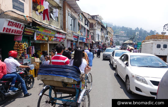
The Crisis of Carrying Capacity: A Multi-Vector Analysis
2.1. The Vehicular and Pedestrian Traffic
Breakdown
The foundational cause of Mussoorie's infrastructural strain is the exponential growth in tourist footfall. Data from the Uttarakhand Tourism Department indicates that the number of visitors nearly doubled in just two years, surging from 11 lakh in 2022 to over 21 lakh in 2024.
This surge has overwhelmed the town's narrow road network and limited civic amenities, turning the routine one-hour drive from Dehradun into a three-hour ordeal for both visitors and residents. Critical choke points, including Gandhi Chowk, Library Chowk, and the stretch between Kingcraig and Zero Point, are in a state of consistent gridlock, particularly on weekends.
The
primary catalyst for this congestion is a severe parking deficit. While
Mussoorie has an official capacity of approximately 2,000 parking spaces, over
6,000 to 7,000 tourist vehicles arrive on weekends, creating a fundamental
imbalance. This forces vehicles to park haphazardly on the roads, effectively
blocking one of the two lanes and creating further obstruction. The problem is
exacerbated by the fact that many hotels and homestays lack adequate parking
facilities, compelling guests to leave their cars on the already congested
streets.
The
consequences of this vehicular chaos extend beyond mere inconvenience. There
are documented human costs, including a tragic incident in which a tourist died
after being unable to reach medical care due to a severe traffic jam.
This
underscores that the issue is not just about slow travel but a matter of public
safety. The presence of large vehicles, as the user notes, further compounds
these problems by monopolizing space on the narrow roads, making it difficult
for pedestrians to navigate safely. The current reality of severe traffic
congestion is already causing economic harm, with tourists actively seeking quieter
destinations and being deterred by the chaos.
This creates a negative feedback loop: the drive to attract more visitors, enabled by new infrastructure, overwhelms the existing systems, degrades the visitor experience, and ultimately risks driving away the very tourism on which the town's economy depends.
The new access
routes, by their very nature, will accelerate this vicious cycle unless the
internal systems are upgraded to match the new capacity.
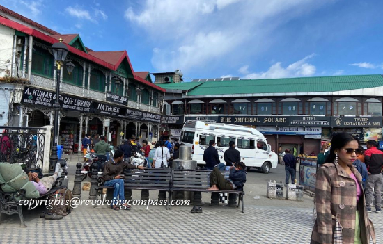 Library Chowk.
Table 2: Tourist Footfall and
Vehicular Traffic Analysis (2022-2024)
|
Year
|
Tourist Footfall (Lakhs)
|
Parking Spaces (app)
|
Vehicle Arrivals (Weekends)
|
|
2022
|
11
|
2000
|
Not Available
|
|
2024
|
>21
|
2000
|
6-7k
|
|
Post Expressway
|
Exponential Increase
|
No significant increase
|
Significant increae
|
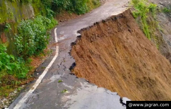
2.2 The Geological Imperative: Landslide
Vulnerability and Unregulated Construction
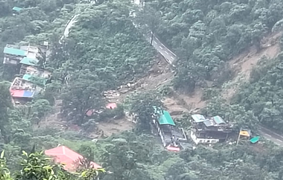
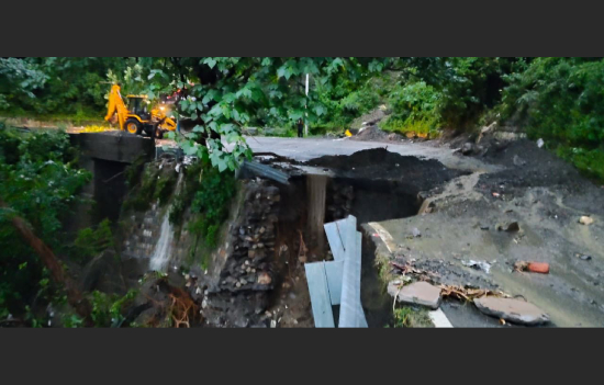
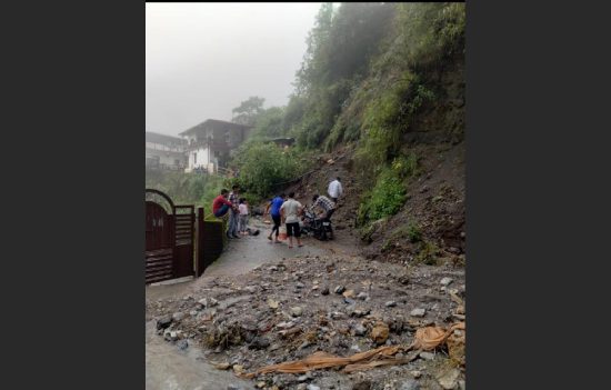
Mussoorie's challenges are not limited to its man-made infrastructure; they are deeply rooted in its fragile geology. The entire Himalayan region is inherently unstable and prone to landslides. This natural vulnerability is being intensified by climate change, which has led to more frequent and intense cloudbursts and erratic rainfall. The problem is that human activity is directly exacerbating these natural risks.
Unregulated development, including "deep excavation for road construction" and "improper discharge of wastewater," has been identified as a key factor in triggering slope failures. These activities disrupt the natural equilibrium of the slopes, making them more susceptible to collapse during heavy rains.
This precarious situation has been scientifically validated. A Landslide Susceptibility Mapping (LSM) study by the Wadia Institute of Himalayan Geology (WIHG) found that 15 percent of the Mussoorie region is "highly susceptible" to landslides. Worryingly, the study found that the dominant portion of this high-risk zone lies within the town's settlement areas, including Bhataghat, Kempty Fall, and Library Road. An additional 29 percent of the area falls within the "moderate landslide susceptible zone," indicating that a significant portion of the town is at risk. The National Green Tribunal (NGT) has sounded the alarm, warning that Mussoorie is at risk of “going the Joshimath way” if these issues are not addressed.
The
underlying problem is a systemic failure
of comprehensive carrying capacity assessment. The recurring landslides in
Uttarakhand, including the disaster in Joshimath, stem from a failure to
conduct and adhere to detailed studies on the maximum number of people,
vehicles, and structures an ecosystem can sustainably support.
While
individual projects like the Delhi-Dehradun Expressway may have undergone an
Environmental Impact Assessment (EIA), the overarching question of whether
Mussoorie as a whole can absorb a massive increase in population and
construction has not been adequately addressed in a single, comprehensive plan.
The new infrastructure, without such a comprehensive, ecosystem-wide
assessment, is a symptom of this deeper, more dangerous planning
void.
 Courtesy Residents of
Mussoourie.
Courtesy Residents of
Mussoourie.
 Courtesy Residents of
Mussoourie.
Courtesy Residents of
Mussoourie.
 Courtesy Residents of
Mussoourie.
Courtesy Residents of
Mussoourie.
Table 3: Landslide Susceptibility
Zones in Mussoorie
|
Susceptibility Zone
|
% of Area
|
Affected Areas
|
|
Very High & High
|
15
|
Bhataghat, George Everest,
Kempty Fall, Khattapani, Library Road, Galogidhar, Hathipaon.
|
|
Moderate
|
29
|
Not Available.
|
|
Low and Very Low
|
56
|
Not Available.
|
3. A Policy and Planning Assessment
3.1. Current and Proposed Mitigation Efforts
In response to mounting pressures, the authorities have initiated a series of mitigation efforts. The most significant is the new mandatory tourist registration system, which came into force on August 1, 2025. The initiative, which was prompted by a National Green Tribunal (NGT) directive, requires tourists to register online and receive a QR code, which will be verified at entry points using Automated Number Plate Recognition (ANPR) cameras. The system's purpose is to provide real-time data on tourist influx, enabling better planning for crowd and traffic management.
Beyond
digital solutions, the administration has also focused on physical
infrastructure. Satellite parking facilities have been established at Hathipaon
and Kingcraig to divert vehicles away from the town centre and ease congestion.
These
parking lots, including a multi-level structure near a petrol pump, are
supported by a proposed shuttle service to transport tourists to central
locations like Picture Palace and Gandhi Chowk. In the short term, authorities
have also resorted to ad-hoc traffic management measures, such as implementing
one-way routes and diverting heavy vehicles at Kothal Gate to prevent gridlock
in key areas.
While these measures are well-intentioned, they face significant challenges in implementation. Hotel owners have expressed concerns that the online registration system could deter last-minute or "spontaneous" tourists, who form a substantial portion of their business. More critically, there is a documented history of inconsistent enforcement.
A public forum discussion revealed that similar registration systems for the Char Dham Yatra were rarely, if ever, checked at checkpoints. This suggests that without strict, consistent enforcement and seamless technical implementation, these policies may remain "a great initiative on paper" rather than an effective crowd-reducing tool.
The current
approach is a collection of reactive and fragmented solutions to individual
symptoms, rather than a cohesive strategy to address the root cause of over tourism
and under-capacity.
Table 4: Summary of
Proposed and Implemented Traffic & Tourism Management Solutions
|
Mitigation Effort
|
Purpose
|
Status
|
|
Tourist Registration
|
Provides real-time data, manage crows,
enforce NGT directives.
|
Implemented as on 1/8/25. Hotels must
register guests. QR code/ANPR for entry proposed.
|
|
Satellite Parking & Shuttle Services
|
Reduce congestion in town centre, provide
off-road parking.
|
Satellite parking operational, shuttle
service planned.
|
|
Ad-hoc Traffic Management
|
Streamline traffic flow, prevent gridlock.
|
Ongoing measures like 1 way plans &
heavy vehicle diversion.
|
3.2. Lessons
from Other Himalayan DestinationsThe challenges facing Mussoorie are not isolated; they are part of a broader "shared Himalayan crisis" stemming from a development model that prioritizes tourist volume over sustainability. Shimla and Nainital, for instance, face identical issues of narrow roads, limited parking, and severe congestion at key choke points during peak season. While these towns have implemented reactive measures, such as deploying additional police and promoting public transport, there is a growing recognition that a long-term solution requires a more fundamental shift in strategy.
The
path forward for Mussoorie can be informed by a strategic redirection away from
mass tourism. Other Himalayan regions and towns have shown that a new economic
model is not only possible but necessary.
The
Niti Aayog has highlighted the potential
for alternative livelihoods such as sustainable agriculture and community-based
tourism (CBT) as a way to eradicate poverty without degrading fragile
ecosystems.
Manali, for example, has embraced sustainable agriculture practices, including organic farming and agroforestry, to diversify its local economy and protect its natural environment. This suggests that a strategic shift from a volume-based to a value-based tourism model—one that fosters eco-tourism and diversifies the local economy—is not just desirable but a matter of ecological and economic survival. This shift would reduce the town's over-reliance on a single, environmentally damaging sector and create a more resilient, sustainable future for Mussoorie and its inhabitants.
4.
Recommendations for a Resilient and Sustainable Mussoorie4.1. An Integrated and Intelligent Transport and
Mobility Strategy
For
Mussoorie to manage the impending influx of tourists, it must implement an
integrated and intelligent transport strategy.
The
first step is to strictly enforce the QR code-based tourist registration
system, particularly during peak seasons, by tying entry to a pre-determined
vehicle and visitor capacity limit informed by real-time data. This will not
only manage crowds but also provide authorities with the data needed for
long-term planning. Secondly, the shuttle service from the new ropeway terminal
and satellite parking lots must be made seamless, reliable, and comfortable to
genuinely encourage tourist adoption and decongest the core town. Finally, the
town should invest in smart city technologies, including Intelligent Transportation
Systems (ITS) and real-time traffic monitoring, to optimize traffic flow and
provide visitors with app-based information on parking availability and
congestion.
4.2. Adherence to Ecological Principles:
Planning with Prudence
The
foundational recommendation for Mussoorie is to conduct a comprehensive
carrying capacity study, as recommended by the NGT, and make its findings the
primary arbiter of all future development. This study should guide a moratorium
on unregulated construction and ensure that all new projects are subjected to
rigorous Environmental Impact Assessments (EIAs) that consider geological
stability and drainage patterns.
In
tandem, the civic infrastructure must be overhauled to address current
deficits. This includes long-term plans for improving waste management,
upgrading sewage systems, and enhancing water supply. The report also
recommends promoting rainwater harvesting to mitigate the severe water scarcity
issues that plague the town, especially during peak tourist season.
4.3. The Future of Mussoorie Tourism: A New
Economic Model
To
ensure its long-term viability, Mussoorie must transition from a model of mass
tourism to one of high-value, low-volume tourism. This requires a strategic
pivot in marketing and policy, positioning the town not merely as a crowded
hill station but as a destination for eco-tourism, adventure, and wellness.
By attracting tourists who are willing to pay a premium for a sustainable and less crowded experience, the town can maintain its economic vibrancy without overwhelming its infrastructure and environment. Concurrently, government and non-governmental organizations should support the diversification of the local economy into other sustainable sectors. This includes promoting organic farming and horticulture, as well as fostering community-based homestays that provide alternative livelihoods for locals and reduce the town's over-reliance on a fragile tourism model.
5. Conclusion: A Call to Action for Balanced Development
The
Delhi-Dehradun Expressway and the Dehradun-Mussoorie Ropeway are not inherently
good or bad; their ultimate impact depends entirely on the long-term vision and
planning that accompanies them. The evidence presented in this report indicates
a dangerous disconnect between ambitious macro-level infrastructure development
and the reality of a town struggling with severe micro-level constraints.
Without a fundamental shift in policy—away from reactive, piecemeal solutions and towards a proactive, integrated, and ecologically sensitive master plan—the new access routes will be the final push that transforms the "Queen of Hills" into a traffic-choked, environmentally degraded shadow of its former self. A strategic master plan, guided by a comprehensive carrying capacity study and enforced with a commitment to sustainable development, is the only path to a resilient and prosperous future for Mussoorie.
To
read article in PDF format, click on
PDF
To read all
articles by author
Also read
1.
Why the Himalayas Need Sustainable Infrastructure- Building Roads,
Breaking Mountains
2.
Floods in North
India - Are We MANUFACTURING DISASTERS
3. Ropeways to Kedarnath and Hemkund Sahib Are AVOIDABLE
4. Topography Climate Change behind heavy rains in the Himalayas