- Who
all built the Grand Trunk road over the last 2000 plus years and what was the
road route.
The
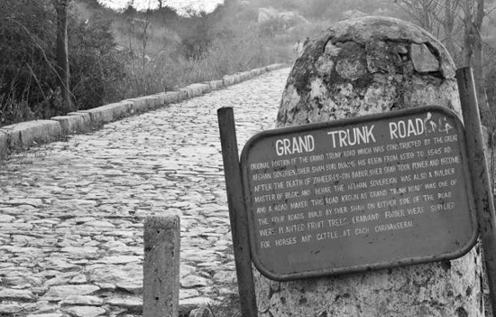
Grand Trunk Road was formerly known as Uttarapath, Sadak-e-Azam, or Badshahi
Sadak. It is one of Asia’s oldest and longest major roads. For at least 2,500
years, it has linked the Indian subcontinent with Central Asia. It runs
roughly 2,400 kilometres from Chittagong, now in Bangladesh, to Kabul in
Afghanistan, passing through Allahabad (now Prayagraj) Howrah, Delhi, and
Amritsar in India and Lahore and Peshawar in Pakistan.
First published in
Journal of Bharatiya Vidya Bhavan.
Chandragupta
Maurya of the Mauryan Empire, built this highway along the ancient route
called Uttarapath or Northern Road in the 3rd century BCE, extending from
the mouth of the Ganges in Bangladesh (also called the Gangetic
delta) to the northwest frontier of the Empire. Further improvements to this
road were made under Ashoka. It was rebuilt many times under Sher
Shah Suri, the Mughals and even the British along a similar
route. The old route was realigned by Sher Shah Suri to Sonargaon in
central Bangladesh and Rohtas in Bihar. The Afghan end of the road was
once rebuilt under Mahmud Shah Durrani of the Afghan Empire. The road was again
considerably rebuilt in the British period between 1833 and 1860.
The
road coincides with the current National Highway N1 (Chittagong to
Dhaka), and then N4 & N405 (Dhaka to Sirajganj in
Bangladesh), N507 (Sirajganj to Natore again in Bangladesh) and N6 (Natore
to Rajshahi in Bangladesh and towards Purnea in India). The road further
moves on NH 12 (Purnea, Bihar to Bakkhali, West Bengal), then NH 27 (Purnea to
Patna), NH 19 (Kolkata to Agra), NH 44 (Agra to Jalandhar via New Delhi,
Sonipat, Panipat, Ambala and Ludhiana) and NH 3 (Jalandhar to Attari, Amritsar
in India and towards Lahore in Pakistan) via Wagah. Then you have N-5 Lahore,
Gujranwala, Gujrat (this Gujrat is a city in Punjab province in Pakistan),
Jhelum, Rawalpindi, Peshawar and Khyber Pass (towards Jalalabad in Afghanistan)
in Pakistan and highway AH1 (that is Torkham-Jalalabad to Kabul) to Gazani
in Afghanistan.
Over
the centuries, the road acted as one of the major trade routes in the region
and facilitated both travel and postal communication. The Grand Trunk Road is
still used for transportation in the present-day Indian subcontinent, where
parts of the road have been widened and included in the national highway
system.
The Buddhist literature and Indian epics such as Mahabharata
provide evidence of the Grand Trunk Road even before the Mauryan Empire. The road
connected India’s eastern region with Bactria, an ancient region in
Central Asia, north of Hindu Kush.
The
road before the modern Grand Trunk road was based on
the highway running from Susa (a city in Iran) to Sardis in
Turkey’s Manisa Province. During the time of the Mauryan
Empire in the 3rd century BCE, overland trade between India and several
parts of Western Asia and the markets of Bactria went through
the cities of the northwest, primarily Takshashila (Pakistan) and Purushapura (modern-day Peshawar in
present day Pakistan).
Takshashila
was well connected by roads with other parts of the Mauryan Empire. The Mauryas
had maintained this very ancient highway from Takshashila to Patliputra
(present-day Patna in India).
Chandragupta
Maurya had a whole army of officials overseeing the maintenance of this road as
told by Greek diplomat Megasthenes who spent fifteen years at the Mauryan
Court. Constructed in eight stages, this road is said to have connected the
cities of Purushapura, Takshila, Hastinapura, Kanyakubja, Prayag,
Patliputra and Tamralipta also known as Tamluk in West Bengal, a distance of
around 2,600 kilometres (1,600 miles).
Chandragupta
built over the ancient Uttarapatha, which was mentioned by Panini, an
ancient Sanskrit philologist, grammarian, and a revered scholar in ancient
India. Emperor Ashoka has recorded in his edict about having planted trees,
building wells at every half kos and
many nimisdhayas, which are often
translated as rest houses along the route. Emperor Kanishka was also known
to have controlled the Uttarapatha.
Sher
Shah Suri, the medieval ruler of the Sur Empire (Sur Empire was an empire
established by a Muslim dynasty of Afghan origin), is known to have rebuilt
Chandragupta’s Royal Road in the 16th century. The old route was further
re-routed at Sonargaon and Rohtas and its breadth was increased.
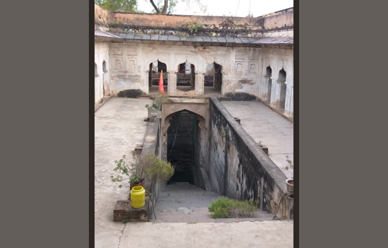 Baori and Sarai at Orchha near Jhansi in Madhya Pradesh.
Fruit
trees and shade trees were planted. At every 2 kms,
a Sarai was built. The number of kos minars (the medieval Indian milestones along
the Grand Trunk Road) and even the baolis were increased. Gardens were also built alongside some sections
of the highway. Those who stopped at the Sarai were provided free food. Sher
Shah Suri’s son Islam Shah Suri also constructed an additional Sarai
in-between every Sarai originally built by Sher Shah Suri on the road towards
Bengal. More Sarais were further built by the Mughals
also. Jahangir under his reign issued a decree that all Sarais be
built of burnt brick (toughened bricks) and stone. Broad-leaved trees were
planted in the stretch between Lahore and Agra. Jahangir also built bridges and
overall water bodies that were situated on the path of the highways. The
route was referred to as ‘Sadak-e-Azam’ by Suri, and ‘Badshahi Sadak’ by the
Mughals.
In the 1830s the East India Company started a programme of metalled road construction, for both commercial and administrative purposes. The road, now named Grand Trunk Road, from Calcutta, through Delhi, to Peshawar (present-day Pakistan) was rebuilt at a cost of £1000/mile. A Public Works Department along with a training institute (the erstwhile Thomson College of Civil Engineering which is now known as the Indian Institute of Technology, Roorkee) was founded to train and employ local surveyors, engineers, and overseers, to perform the work, and in future maintain it along with other roads.
The
road is mentioned in a number of literary works including those of Foster and
Rudyard Kipling. Kipling described the road as: “Look! Look again! and chumars,
bankers and tinkers, barbers and bunnias, pilgrims and potters-all the
world going and coming. It is to me as a river from which I am withdrawn like a
log after a flood. And truly the Grand Trunk Road is a wonderful spectacle. It
runs straight, bearing without crowding India’s traffic for fifteen hundred
miles-such a river of life as nowhere else exists in the world.”
The
ensemble of historic sites along the road in India was submitted to
the tentative list of UNESCO World Heritage Sites in 2015, under the
title ‘Sites along the Uttarapath, Badshahi Sadak, Sadak-e-Azam, Grand
Trunk Road’.
Psephologists sometimes
refer to the area around the GT Road as, ‘GT Road Ambala to Sonepat sector,
which has 28 legislative assembly seats’ in the context of elections. During
the elections in Haryana, the area on either side of the GT Road form
constituencies where there is no dominance of one caste or community. So, it is
referred to as the ‘GT road belt of Haryana’
This article was
first published in the Bhavan’s Journal, 30 November 2022 issue. This article
is courtesy and copyright Bhavan’s Journal, Bharatiya Vidya Bhavan,
Mumbai-400007. eSamskriti has obtained permission from Bhavan’s Journal to
share. Do subscribe to the Bhavan’s Journal – it is very good.